
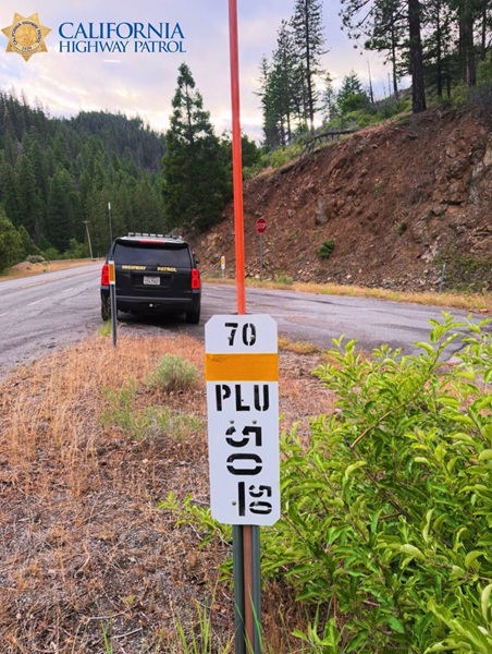
When driving down a rural highway or an unfamiliar stretch of state road, landmark references like interstates or major intersections aren’t always visible. In a sudden roadside emergency—whether it’s a vehicle crash, a brush fire, or a debris hazard—describing your exact location to dispatchers can prove challenging.
That is where post mile markers come in. These small, narrow white signs placed along state highways serve as precise geographical reference points, giving emergency responders the critical data needed to route aid instantly when seconds count.
Reading the Code
While post mile markers may look like random numbers and letters at a quick glance, they follow a straightforward, standardized top-to-bottom key:
-
Top Number: Identifies the state highway or route number you are traveling on (e.g., 70 for State Route 70).
-
Middle Letters: Displays the three-letter abbreviation for the county you are currently in (e.g., PLU for Plumas County or LAS for Lassen County).
-
Bottom Numbers: Indicates your exact distance in miles from the county line, usually measured moving south-to-north or west-to-east.
For instance, if a marker reads 70 on top, PLU in the middle, and 50.50 at the bottom, you are located on State Route 70 in Plumas County, precisely 50.50 miles from the county line.
What to Do in an Emergency
If you need to call emergency dispatch while on a highway and there are no nearby cross streets or prominent exit signs, scan the shoulder for the nearest post mile marker. Relaying those three lines of text directly to dispatchers eliminates guesswork, allowing first responders to navigate straight to your location without delay.