
Kane Springs and Grapevine Fires Update
Location: Lincoln County, Nevada, South of Caliente
For Immediate Release
Contact: Jacob Chadwick, [email protected], 775-399-8248
Kane Springs and Grapevine Fires Continue to Challenge Firefighters in Rugged Terrain
Incident Overview
Lincoln County, NV. — Interagency wildland firefighters continue suppression efforts on the Kane Springs and Grapevine Fires burning south of Caliente.
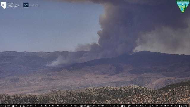
The Kane Springs Fire is currently estimated at 14,915 acres and 20% contained. Updated mapping conducted overnight provided a more accurate picture of the fire perimeter, accounting for both recent fire growth and previously unconfirmed areas within the fire edge. The fire continues to burn in short grass, brush, and pinyon-juniper fuels southwest of Caliente.
The Grapevine Fire is currently estimated at 13,196 acres and remains 0% contained. The fire is burning in timber and steep, rugged terrain within the Clover Mountain Wilderness Area southeast of Caliente. Firefighters continue to face challenging conditions due to difficult access, steep canyons, and heavy fuels in portions of the fire area.
Response Actions
On the Grapevine Fire, firefighters successfully completed a burnout operation along the northwestern portion of the fire yesterday evening. The operation strengthened containment lines and helped secure the fire edge within established control features. Today, crews and engines are working to secure and patrol the area affected by the burnout while continuing suppression efforts across the incident.
In the more remote portions of the Grapevine Fire, hotshot crews are engaging the fire where terrain and conditions allow while continually evaluating firefighter safety in steep canyon systems. Additional divisions and resources are being considered to improve access and strengthen suppression efforts in these areas.
On the Kane Springs Fire, crews remain engaged in direct suppression where conditions allow and continue strengthening containment lines around the fire perimeter. Ground resources are utilizing existing roads, dozer line, and natural barriers to secure and improve containment features. Firefighters continue to adapt tactics to changing conditions while working to protect values at risk and strengthen containment across the incident.
Weather and Fire Behavior
Hot, dry weather and low humidity continue to support active fire behavior across both incidents. Steep terrain, dry vegetation, and afternoon winds remain significant challenges to containment efforts. Fire managers are also monitoring the potential for thunderstorms in the coming days, which could bring erratic winds and influence fire activity.
Closures / Public Safety
There are currently no evacuations associated with either fire. Residents and travelers are encouraged to remain aware of changing fire conditions and exercise caution while recreating or traveling in the area.
The public is reminded to avoid flying drones near wildfires. If you fly, we can’t.
For the latest information:
Kane Springs Fire InciWeb: https://inciweb.wildfire.gov/incident-information/nveld-kane-springs
Ella Mountain Fire Camera: https://alertnevada.live/cam-console/12193
Grapevine Fire InciWeb: https://inciweb.wildfire.gov/nveld-grapevine
Highland Peak Fire Camera: https://alertnevada.live/cam-console/12201
For real-time maps, fire cameras, and fire restrictions, visit: NevadaFireInfo.org
Air Quality & Smoke Information
Smoke may be visible from surrounding communities and travel corridors. Individuals sensitive to smoke should limit outdoor activity when conditions worsen and monitor air quality at www.airnow.gov.


