
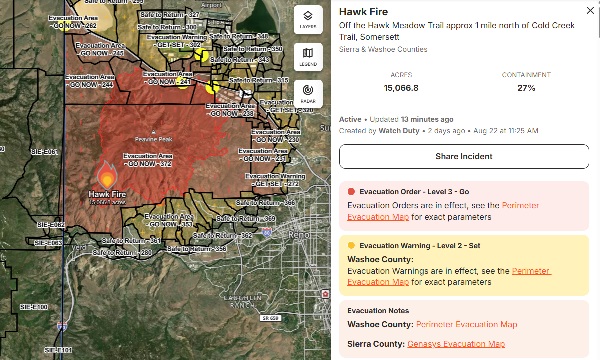
Acres: 15,051
Start Dates: August 22, 2026
Containment: 27%
Causes: Human
Total Personnel: 816
Fuels: Tall grass, brush and timber
Total Resources: 14 crews | 81 engines | 10 helicopters | 9 dozers
Location: Northwest of Reno, Nevada
Summary: Great Basin Incident Management Team 6 arrived and assumed management of the incident from the initial response team. Firefighters continued to make progress, increasing containment of the fire to 27 percent. The Hawk Fire has significantly affected homes and community structures, and extensive work remains as damage assessment teams continue accessing impacted areas. The number of confirmed destroyed or damaged structures may rise as assessments progress. On the first day, the fire exhibited extreme behavior, moving approximately four miles in three hours and covering a total distance of six miles, contributing to the breadth of impacts now being evaluated. Critical infrastructure, including a threatened railway line and a communication tower, has also been affected. A full suppression strategy is being implemented to reduce or eliminate risk to communities, infrastructure, recreation sites, and natural and cultural resources. Incident strategies and tactics prioritize actions with the highest probability of success while minimizing risk to firefighters and the public. Although current suppression efforts and control features are limiting projected fire movement, forecasted winds and gusts over the next few days are expected to challenge containment lines.
Fire Outlook and Weather: A low probability of thunderstorms and outflow winds are possible for the next few days. Continued critically dry fuels persist in the area with the possibility of continued elevated temps and seasonal afternoon southwest to west winds.
Evacuations and Closures: Some area, road and trail closures remain in effect, including areas southbound off U.S. Highway 395 and a Forest area closure. Travelers and residents should check current road and evacuation information before entering the affected area. Authorities are asking the public to remain vigilant and be safe as fire suppression efforts continue in the area. The most current information and updates for evacuations and closures for the Hawk Fire can be found at Perimeter Map. Residents in affected areas should continue to follow evacuation information and direction from local authorities.
Safety: Temporary Flight Restrictions (TFRs) are in place, please remember if you fly drones during a fire, we can’t safely operate air support which hinder suppression efforts and emergency response, this puts the crews and public at risk. “If you fly, we can’t!” If you or a loved one is sensitive to smoke, stay indoors when possible until air quality improves. Monitor current air quality through the AirNow.gov