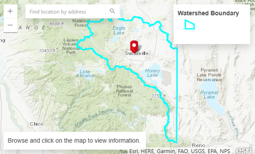
Precipitation in the Honey–Eagle Lakes Watershed is tracking above historical averages so far in the current water year, according to California Water Watch data as of July 4, 2026.
The watershed is part of a closed basin system that straddles the California–Nevada state line, with most of the drainage area located in California. The region is monitored as part of broader statewide efforts to document water supply and climate conditions across different hydrologic regions.
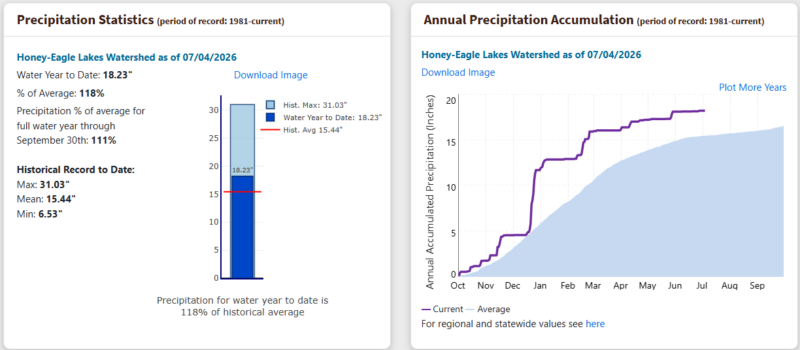
State data shows that the watershed has received 18.23 inches of precipitation to date, which is 118% of the historical average for this point in the water year. When measured across the full water year, precipitation is tracking at 111% of average, according to long-term records dating back to 1981.
The historical mean annual precipitation for the watershed is listed at 15.44 inches, with recorded extremes ranging from a low of 6.55 inches to a high of 31.03 inches over the period of record.
(California Water Watch)
A cumulative precipitation chart included in the state’s dashboard shows current-year totals trending above the long-term average curve through most of the water year, including increases during winter and early spring precipitation periods.
The Honey–Eagle Lakes Watershed is part of California’s statewide hydrologic monitoring network, which compiles precipitation and temperature data to provide near real-time conditions and historical comparisons across watersheds.
California Water Watch data is informational and is used by the public, water managers, and researchers to track conditions over time and compare current-year precipitation to historical norms.