
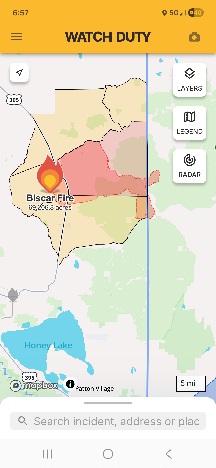
Firefighters in northeastern California are battling the rapidly expanding Biscar Fire, The Biscar Fire started on July 18, 2026 within Lassen County. It grew quickly with warm temperatures and strong winds pushing it eastward across Highway 395. The fire has been mapped at 69206 acres by Intel Aircraft as of 7/21/26.. Driven by hot weather and intense wind gusts, the wildfire pushed east across Highway 395 and crossed the state line into Nevada.
As of Tuesday, the blaze remains 5% contained. There are currently 400 personnel on the fire. The Lassen County Fairgrounds is being used as Fire Camp to support the Biscar Fire.
There was about 10,000 acres of growth yesterday (July 20), primarily to the south and east.
Several Large Air Tankers were utilized last night to slow the growth of the fire to the east. Crews, engines, and dozers continue to work direct on the fires edge to slow the growth. The threat of thunderstorms in the area increases today and tomorrow, bringing chances for scattered rain, strong winds, and lightning.
Evacuation Orders: Orders have been issued for the following areas – LAS-543, LAS-551-A, LAS-551-B, LAS-551-C, and LAS-553. An evacuation order is issued when there is an immediate threat to life. This is a lawful order to LEAVE NOW. The area is lawfully closed to public access.
Evacuation Warnings: Warnings have been issued for the following areas- LAS-54, LAS-545, and LAS-555 An evacuation order means there is a potential threat to life and/or property. Those who require additional time to evacuate, and those with pets and livestock should leave now.
Interactive Evacuation Map is available through Genasys Protect.