
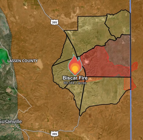
Start Date: July 18, 2026
Size: 69,344 acres
Cause: Under Investigation
Location: Lassen County, CA / Washoe County, NV
Percent Contained: 42 %
California Team 3: Oscar Vargas, IC
Fire Resources: 509 personnel.
Fire Activity: Fire Activity: Firefighters have established good containment lines along the western flank, from Vincent Springs to Secret Creek and to Rye Ranch Springs. Crews continue to strengthen this line and mop up hot spots. On the southern side, firefighters are making solid progress building fire lines near Rush Creek. Along Smoke Creek to Wilcox Canyon (eastern flank) crews are actively constructing direct containment lines.
Fire Weather: Weather conditions have remained favorable for firefighting efforts, but a shift is on the way. Conditions are expected to change today, with hot, very dry, and increasingly windy weather building Friday and Saturday. Firefighters are preparing for these conditions, which could bring increased fire activity later in the week.
Evacuations Orders:
California
Evacuation Orders: Evacuation orders remain in effect for zones LAS-543 and LAS-553. An evacuation order means there is an immediate threat to life. This is a lawful order to leave now — the area is closed to public access.
Evacuation Warnings: Evacuation warnings are in effect for zones LAS-551-A, LAS-551-B, LAS-551-C, LAS-545, and LAS-555. An evacuation warning means there is a potential threat to life and/or property. Residents who need additional time to evacuate, including those with pets or livestock, should leave now.
Interactive Evacuation Map is available through https://protect.genasys.com/
For shelter information call (530) 254-4500: or visit the Lassen County Sheriff’s Office Facebook: https://www.facebook.com/LassenSheriff/
Nevada
- Level 2 (Set), and Level 3 (Go Now) Evacuation recommendations have been issued for portions of central Washoe County.
- Interactive Evacuation Map is available through https://experience.arcgis.com/experience/46cb79ef933d4485b9966a9730e2d944/page/Perimeter/
Area Closures: The Bureau of Land Management has instituted a temporary closure of public lands for the Biscar Fire. Public lands near Snowstorm Road and Vincent Canyon, northeast of Susanville in Lassen County, are closed for wildland fire fighting operations. Pursuant to 43 CFR 8364.1, this temporary closure is being implemented for public and firefighter safety during emergency fire suppression actions. View the Full Closure Order and Map.
Fire Restrictions: The Bureau of Land Management issued seasonal fire restrictions effective July 15th for BLM-managed public lands within Lassen, Modoc, Plumas, Sierra, Siskiyou and Shasta counties in California and Washoe County, Nevada. These seasonal restrictions are in addition to the year-round, statewide fire prevention order. These fire orders or Applegate and Eagle Lake field offices are in place to help prevent wildfire and will remain in effect until further notice. The fire restrictions prohibit campfires and barbecues except within established campfire rings and barbecue grills in certain designated recreation sites: Read more at https://www.blm.gov/announcement/blm-announces-seasonal-fire-restrictions-ne-california-nw-nevada-0
Highway Closures: Highway 395 is open. Please use caution when traveling in the area as firefighters may be working near the roads and anticipate an increased amount of heavy equipment between the fire area and Susanville. https://roads.dot.ca.gov/?roadnumber=395 .
Smoke Impacts: Please visit https://fire.airnow.gov/?lang=en#7.34/40.599/-119.644 for smoke information from the Biscar Fire. For information about the impacts of smoke, and ways to protect your health, please visit https://www.airnow.gov/air-quality-and-health/fires-and-your-health/