
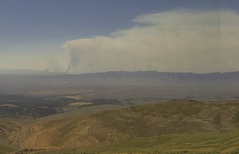
Location: Lincoln County, NV on Nevada Test and Training Range (NTTR) withdrawn lands and BLM lands within the BLM Ely District.
Possibly visible on fire cameras at Alert Nevada
Size & Containment: Approx. 12,990 acres and 7% contained as of 6:00 PM 7/29/26. Fire activity was minimal, with the fire slowly creeping through vegetation and backing into the wind rather than making rapid runs. Improved aerial mapping also refined the estimated fire acreage.
Evacuations: No evacuations and no publicly accessible structures are threatened.
Closures: The Quail Springs Fire is within the Nevada Test and Training Range (NTTR) withdrawn lands. This is a restricted area, closed to the public, always, regardless of fire activity. No closures are in effect. Highway 375 may be impacted by smoke depending on fire behavior. If contingency plans are activated, Highway 375 may experience temporary closures, but no closures are planned.
Threatened
No residences or public spaces are threatened. The nearby community of Rachel, NV may be impacted by smoke but is not threatened.
Update: Firefighters reported one of their most productive operational periods so far. Helicopters supported suppression efforts while crews focused on the north side of the fire, constructing contingency lines and reinforcing them with retardant. Ground crews plan to secure those lines during the next operational period. Fire managers continue monitoring isolated heat on the west side while maintaining additional contingency plans if fire activity increases. Active fire behavior remains possible during the afternoon, including rapid fire spread and spotting, where wind carries burning embers ahead of the main fire and starts new ignitions.
Fire Outlook: Hot, dry weather will continue through the week, with daytime temperatures in the upper 80s to around 90 degrees. Southwest winds of 10–15 mph will shift to the west overnight. Very dry air and poor overnight moisture recovery could keep the fire to remain active into the night.
Objective: Firefighters will continue constructing and strengthening containment lines to limit fire growth to the north, south, and east. In areas where steep terrain or fire conditions make it unsafe to work directly on the fire’s edge, crews will strengthen containment lines ahead of the fire and engage it directly when conditions improve.
Visit Great Basin Coordination Center for more weather and risk potential.
Fire Summary
Report date: 07/25/2026 approx. 8:22 AM PDT
Jurisdiction: Nevada Test and Training Range
Cause: Natural, Lightning
Fuels: Timber (Pinyon/Juniper) and grass
Responding Agencies: United States Air Force, US Wildland Fire Service, Lincoln County Emergency Management Department
More information:
NevadaFireInfo.org: real-time fire maps and cameras – fire restrictions – prevention, safety – and fire career opportunities in Nevada.
We urge the public to remember – If you or a loved one is sensitive to smoke, stay indoors when possible until air quality improves. Monitor air quality at: NWS Air Quality