
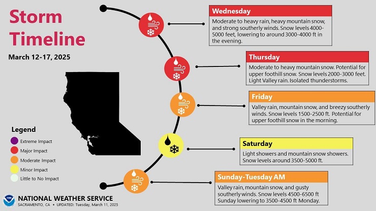
A series of storms that will impact California over the next week. After mild and mostly sunny conditions today and Tuesday, the first system arrives overnight Tuesday with rain likely across the foothills by sunrise Wednesday. This system has a good amount of moisture, and we may see 2+ inches of rain in the foothill belt by the time it winds down late Thursday. Heaviest rain will be during the day on Wednesday, especially in the afternoon when the front is forecast to move through. Below is the GFS model for 2:00pm on Wednesday.
On Thursday the front will be to the east with scattered showers, mostly over the mountains by Thursday afternoon. We are entering into that time of the season when the sun is at a higher angle which promotes thunderstorm activity. Best chance for thunderstorms will be in the valley but we may see some cells migrate up into the foothills. Always a chance of brief heavy rain and hail if one passes overhead. Winds will be moderately strong, mainly on Wednesday with gusts up to 30-40mph.
Ok….here’s the big bugaboo. Snow. I’m already seeing wild comments on social media about heavy snow in the foothills. There is a chance snow levels could lower down to 1500-2500 but this will not be a big snow event below 3500. Best chance for snow at those lower elevations will be Wednesday night into Thursday morning. This will be after the front has moved through so the heaviest precipitation will be past. This is not a convergence of cold air and a frontal system, but a more typical inflow of colder air behind the front. I think there is a pretty good chance of some light accumulations by mid-day Thursday, but this will not be a high-impact snow for the foothills – if any.
This will however be a good snow producer in the mountains with 2 feet of new snow expected over Donner Pass and with the colder nature of the storm we will likely see some good snow accumulations at Lake level around Truckee/Tahoe City of 1 to maybe 2 feet.
Another system will move through on Friday into Friday night. This system will be weaker with most of the energy staying north over the Shasta/Lassen region. It looks like snow levels will remain just above town, but we may see snowflakes or very light snow on Friday. The upper foothills may see some additional light accumulations. A third storm arrives Saturday night into Sunday. This is still 6-7 days out but right now it has the potential to be as strong as the Wednesday/Thursday storm. Stay tuned!


